$5 shipping
for up to 9 standard prints!
Vintage Visualizations
Prints & posters of old maps, historic data viz and infographics from ages long past
View cart
Your cart
0 Items
Featured
Census Atlases
Survey Maps
Botanical Prints
"No Apples"
Your cart (0)
Millions of Maps
Featured
Census Atlases
Survey Maps
Botanical Prints
"No Apples"
Your cart (0)
Sort by
Featured
Price: Low to High
Price: High to Low
A-Z
Z-A
Oldest to Newest
Newest to Oldest
Best Selling
Millions of Maps
color
State
new!
All
Details
All
four maps
six maps
seven or more maps
bar graphs
Orientation
All
horizontal
vertical
All Filters:
All
agriculture
bar graphs
bread
Census Atlas
charts
color
colorful
disease and mortality
east coast
four maps
front page
green
horizontal
interesting and unique
jobs and education
monochrome
multicolor
orange
politics
Population
race and ethnicity
red
religion
seven or more maps
six maps
vertical
west coast
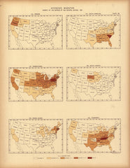
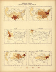
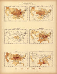
Interstate migration ... : 1890 (NM, NY, NC, ND, OH, OK)
Interstate migration ... : 1890 (OR, PA, RI, SC, SD, TN)
Interstate migration ... : 1890 (TX, UT, VT, VA, WA, WV)
Interstate migration: 1890
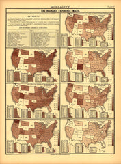
Mortality (Life Insurance Experience -- Males)
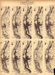
Pacific coast
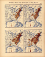
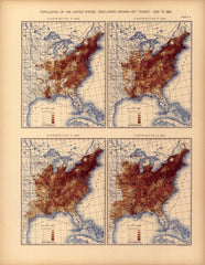
Population of the United States: 1790 to 1820
Population of the United States: 1830 to 1860
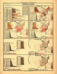
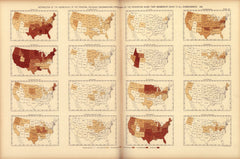
Presidential Elections - 1824 (Adams), 1828, 1832 (Jackson), 1836 (Van Buren), 1840 (Harrison)
Religious Denominations by State
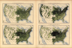
Yield of indian corn per square mile: 1890
Yield of oats per square mile: 1890
1
2
3