$5 shipping
for up to 9 standard prints!
Vintage Visualizations
Prints & posters of old maps, historic data viz and infographics from ages long past
View cart
Your cart
0 Items
Featured
Census Atlases
Survey Maps
Botanical Prints
"No Apples"
Your cart (0)
Millions of Maps
Featured
Census Atlases
Survey Maps
Botanical Prints
"No Apples"
Your cart (0)
Sort by
Featured
Price: Low to High
Price: High to Low
A-Z
Z-A
Oldest to Newest
Newest to Oldest
Best Selling
Millions of Maps
State
new!
All
Details
All
four maps
six maps
seven or more maps
bar graphs
Orientation
All
horizontal
vertical
All Filters:
All
agriculture
bar graphs
bread
Census Atlas
charts
color
colorful
disease and mortality
east coast
four maps
front page
green
horizontal
interesting and unique
jobs and education
monochrome
multicolor
orange
politics
Population
race and ethnicity
red
religion
seven or more maps
six maps
vertical
west coast
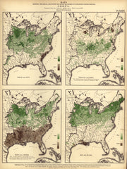
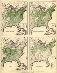
Crops (wheat & rice, tobacco & hops, oats & cotton, hay & sugar)
Distribution of Deaths from Disease (Scarlet Fever, Diphtheria, Malaria, Etc)
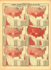
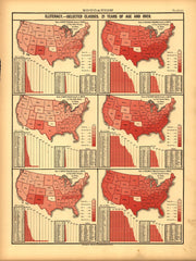
Education (Illiteracy -- 10 Years of age and over)
Education (Illiteracy -- 21 Years of age and over)
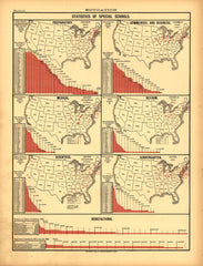
Education (Statistics of Special Schools)
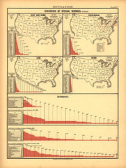
Education (Statistics of Special Schools, Retrospect)
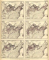
Foreign population (British, English & Welsh, Swedish & Norweigian)
Foreign population (Irish, German)
Improved land in farms; Total agricultural production; Corn; Dairy products
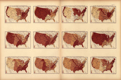
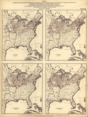
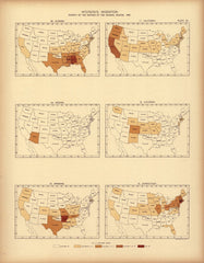
Interstate migration ... : 1890 (AL, AZ, AK, CA, CO, CT)
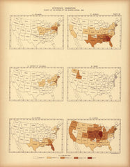
Interstate migration ... : 1890 (DE, DC, FL, GA, ID, IL)
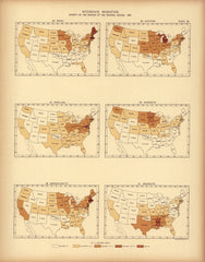
Interstate migration ... : 1890 (ME, MD, MA, MI, MN, MS)
1
2
3